

LUNAR INFRASTRUCTURE FOR SIMULATIONS OF LANDING SCENARIOS PROJECT


DTM based simulation
Purpose:
The generation of 3D datasets and simulations from real Digital Terrain Models (DTMs) are a resource for assessing Lulav’s computer vision navigation algorithms for space missions.

Infrastructure

NASA Lunar Topography SLDEM2015 Dataset

TIFF file
NASA's Lunar Orbiter Laser Altimeter (LOLA) aboard the Lunar Reconnaissance Orbiter (LRO) has collected 43,200 TC DEM tiles to produce a combined topographic map of the Moon at a resolution of 512 ppd.
NASA's DTMs are segmented into smaller tiles, which serve as the basis for generating high-resolution meshes. This segmentation later enables the execution of a real-time dynamic simulation wherein dynamic imports are employed based on the input scenario - position of the starship in time).

GAEA
GAEA is a terrain design tool that enables the creation of a 3D obj mesh from an input tiff file. The addition of synthetic data in Gaea enables synthetic increase in the terrain resolution.
Synthetic data
Synthetic details are added with softwares such as Gaea and blender for achieving synthetic
higher resolution. Small craters, rocks and different kinds of realistic terrain textures are applied..


Before
After
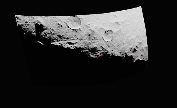
Try exploring it yourself -- you can zoom in and out, and rotate the view. This is a real crater somewhere on the moon!
(Note, the model was downscaled due to size limitations)
Seamless Tiling
Braking simulations require large-scaled and high detailed terrains that are seamlessly tiled, however tiles before preprocessing cannot be tiled because of the synthetic data addition.


Preprocessing is executed using python; The meshes are loaded as numpy arrays with Pymesh library. Scaling and transformations are applied, and a weighted average is computed between overlapping meshes to create seamless tiles.


Coordinate Transformation
The generated meshes are composed of vertices that are based on latitudinal coordinates. Using NASA’s meta-data of the appropriate mesh, each vertex is converted to rectangular coordinates with the help of the SpiceyPy library. Finally, a new mesh is constructed, and the surface is now a part sphere with accurate representation of the moon.


Blender Rendering

Blender is a 3D computer graphics software tool that enables the creation of the simulation via python API.


The simulation is created using the Blender.
Simulation frames are seamlessly integrated using input camera positions, while the corresponding meshes are dynamically imported along with the dynamic application of textures.
Dynamic importing enables the rendering of highly detailed and high-resolution meshes that demand significant memory, more than any 3D software can handle.
Camera View
Side View
